


Situation report from Station Nord – Leg 3
Situation report from Station Nord – Leg 3
We are a team looking into the oceanographic conditions at St Nord (81°N). This year we have focus on how sea ice and glaciers interact with the ocean. We are a part of the Arctic Science Partnership and we are the third team to come up here. Two other campaigns have already been conducted in early spring. We focus on the short summer period where sea ice has started to melt away. Recent years have been special. Normally sea ice survives the summer and turn into old multiyear sea ice that covers the area year round. Only within the last years sea ice has started to melt entirely in the bay around St Nord and we cannot access the area with skidoos anymore, but need small boats to navigate.
For safety we have brought an airboat as well if sea ice closes in on us in the boats. The area is a challenge for navigation as weather and ice conditions are highly dynamic. One morning all ice has gone and it is easy to go far away from the station. But on our return everything is closed with ice again and we are struggling 6 hours to make the same distance that took 15 minutes to pass by boat in the morning. This teaches us to read the conditions carefully and adapt our program to what nature bring. Hence, we are standby with different sampling strategies and procedures and can change plans in minutes. It also teaches us to be patience and humble.
The core in our program is to map the bathymetry and the salinity and temperature conditions in the ocean around Station Nord and we have made numerous vertical and horizontal profiles (so called CTD profiles) in the area already. Other instruments also measure light, chlorophyll, oxygen, carbon dioxide, turbidity, particle size, pH, and currents. Samples are collected for nutrients, primary production, bacterial production, carbonate chemistry, oxygen, carbon and nitrogen isotopes. These samples are processed in the well-equipped laboratories at the Villum Research Station up here. We also bring newly developed equipment for test in this cold environment including a fast responding ‘optocop’ to measure CO2 in seawater.
We have also been sampling old multiyear sea ice. Melt ponds cover sea ice at this time of year. Some are isolated lakes with no connection to the ocean below. Other lakes are connected to the underlying water through holes in the sea ice. These ponds make an interesting environment for algae, bacteria and meiofauna. They are also sites of complicated chemical processes affecting the CO2 exchange between the atmosphere and ocean.
Sampling melt ponds on a multiyear ice floe.
The intense sea ice melting and runoff from land during the short summer thaw makes surface waters very brackish. It reminds us of the conditions in the Bothnian Bay. In addition, numerous icebergs are released into the ocean from the Flade Isblink. This also affects the salinity and current conditions in the ocean although it is a little more difficult to predict how. Few years ago an underwater lake under the ice cap was released into the bay and we are trying to find out how emptying of lakes and meltwater from subglacial discharge affect water properties around Greenland. One way is to capture the signals with our moorings that measures year round. In early spring, several moorings were deployed in the area that will collect data in the ocean every 10 minutes until next summer where we will retrieve them. Some of them transmit data through satellite links so we can follow conditions from our offices back home.
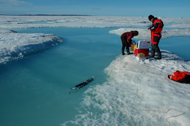
Another way is to go close to the icebergs and glacier terminus to look at water properties directly. This is a little dangerous as icebergs can rotate and the glacier terminus can break off producing tsunamis that is not well suited for our small zodiac boats. Therefore we have brought an underwater vehicle (AUV) to map conditions near the glacier front and around icebergs. Hereby we can position us in a safe distance from the site and remotely control our AUV to make these measurements. It has proven a great success and this new technology is perfectly suited to map the vertical and horizontal variability of melting processes and plumes of freshwater. We have had some very interesting days between icebergs with thunder sounds and breaking up of glaciers and icebergs with tsunamis well suited for our zodiacs. Nice to be floating at safe distance.
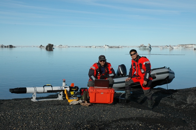
Preparing the AUV for deployment.
We have 4 days back of our work and most of our work program been accomplished. Then we need to pack down a LOT of equipment and send everything back to our institutes in Canada, Greenland and Denmark. The Arctic summer has been treating us well.